Back to top

Climate change may affect the city’s coastline


Various studies on the effects of climate change show that in the coming years there may be changes in climatic phenomena related to the sea with global effects. Due to the geographical and climatic characteristics of our region, the factor that could have the greatest impact on the city of Barcelona is the rise in the average sea level, although trends in the variability of sea storms and variations in wind and pressure also play a very important role.
These changes can have consequences on the elements that make up the coastline: beaches and port infrastructures. However, this chapter deals exclusively with the consequences of climate change on beaches. In this regard, the dangers associated with rising sea levels are twofold: those directly associated with flooding and those which, in addition to changes in wave trends, may modify the current morphology of beaches, affecting their orientation and the processes of erosion and accretion
Inundation caused by sea level rise is calculated from three overlapping parameters: the localised rise in average sea level due mainly to melting ice and thermal expansion that causes permanent inundation; the astronomical tide and changes in pressure and wind (meteorological tide) that generate potential inundation; and, finally, the effect of waves that cause extreme flooding.

Augment de la temperatura
Diagram of factors behind permanent and potential rises in sea level. Source: Barcelona Regional


At present, waves are responsible for causing the most significant problems on the Barcelona coastline when extreme episodes of storms occur.

Future projections


Sea level rise has been analysed for two climate change scenarios: the committed scenario, which corresponds to a global reduction in emissions in accordance with the Paris agreements (RCP4.5 scenario); and the passive scenario, which corresponds to a continuation of the current rate of emissions (RCP8.5 scenario), and for two time horizons: mid and end of the century.
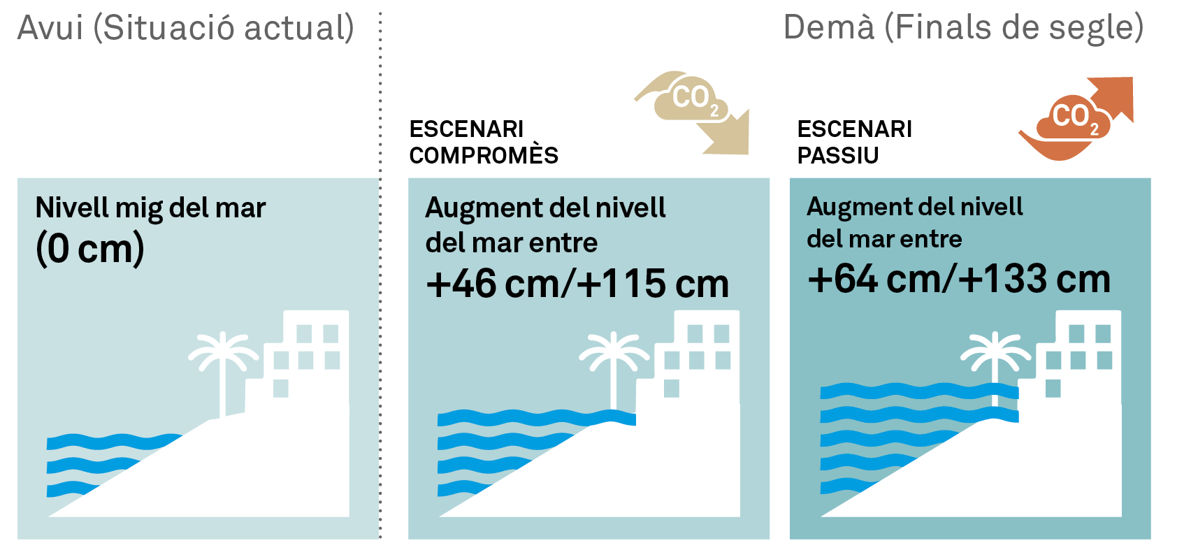
In the year 2100, the increase in average sea level due to climate change on our coastline is expected to be 0.46 metres (committed scenario) and 0.64 metres (passive scenario). If, in addition, the effect of the tide and changes in pressure and wind are taken into account, the values would be 1.15 metres and 1.33 metres, respectively.

Augment de la temperatura

In addition, another scenario has also been evaluated for 2040, the ‘baseline’ scenario, which is based on the extrapolation, in the long term, of the trend in the historically observed flood level. Finally, the ‘most pessimistic’ scenario for the end of the century has been analysed, which responds to current concerns about the stability of the Greenland and West Antarctic ice sheets (even though the probability of this episode is low, the serious consequences mean that it cannot be ruled out).
The baseline scenario would indicate a total sea level rise of 1.69 metres by 2040, while the pessimistic scenario predicts an average sea level rise of 2.00 metres by 2100 which could be as high as 2.69 metres if tidal effects and changes in pressure and wind are also taken into account.
Predictions of sea level rise for the different scenarios have been made on the basis of literature studies. The maximum potential sea level rise for the different scenarios and time horizons are detailed below.

Projected maximum sea level rise for the period 2046-2065

Considering the permanent and potential flooding components (astronomical and meteorological tide) together, for the period 2046-2065 the total rise would be 0.94 m for the committed and passive scenarios, as the differences between one and the other for this period are minimal.

Augment de la temperatura
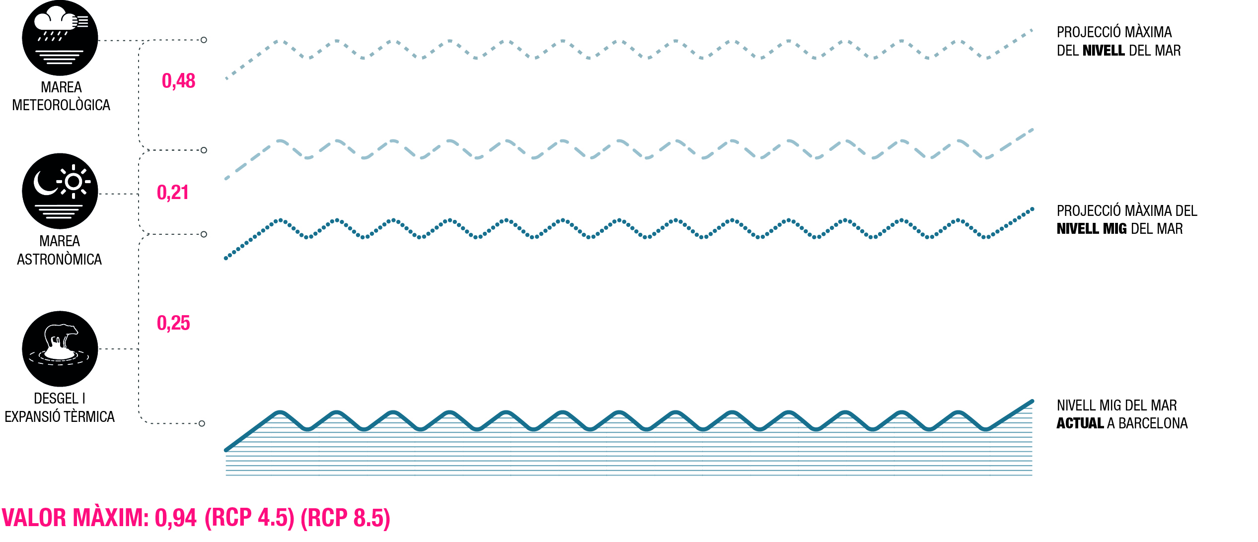
Projected maximum sea level rise for the period 2046 to 2065. Committed and passive scenario. Source: Barcelona Regional

In contrast, considering the 2040 projections of the baseline scenario, the total sea level rise would be much higher, reaching 1.69 metres.

Projected maximum sea level rise for the period 2081-2100

Considering the permanent and potential flooding components (astronomical and meteorological tides) together, for the period 2081-2100 the total rise would be 1.15 metres for the committed scenario and 1.33 metres for the passive scenario.

Augment de la temperatura
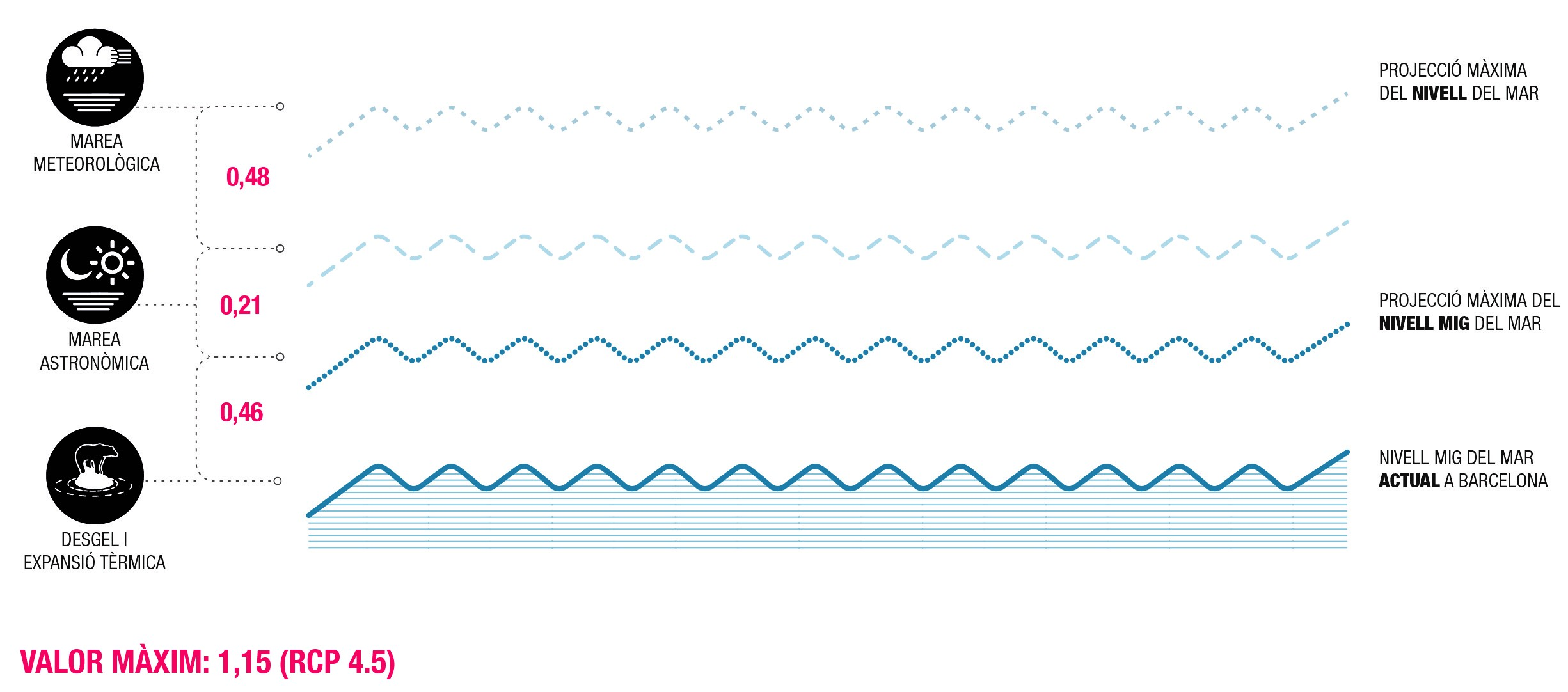
Projected maximum sea level rise for the period 2081 to 2100. Compromised scenario. Source: Barcelona Regional

Augment de la temperatura
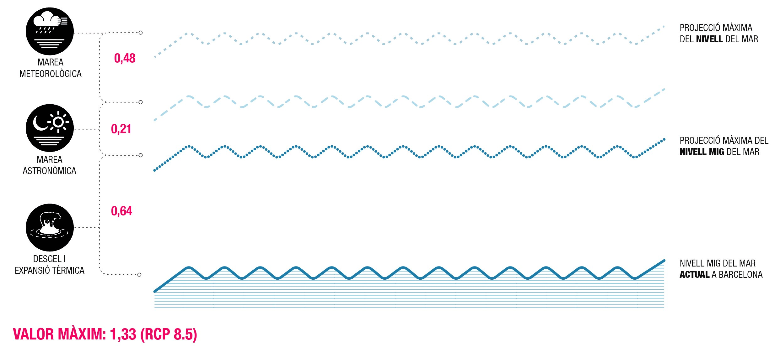
Projected maximum sea level rise 2081-2100. Passive scenario. Source: Barcelona Regional

Conversely, considering the pessimistic scenario, the rise in relation to the current sea level by 2100 would be 2.69 metres, where, as in the previous cases, 0.48 metres corresponds to the meteorological tide and 0.21 metres to the astronomical tide, but the increase in the average sea level would be 2.00 metres.

Extreme flooding

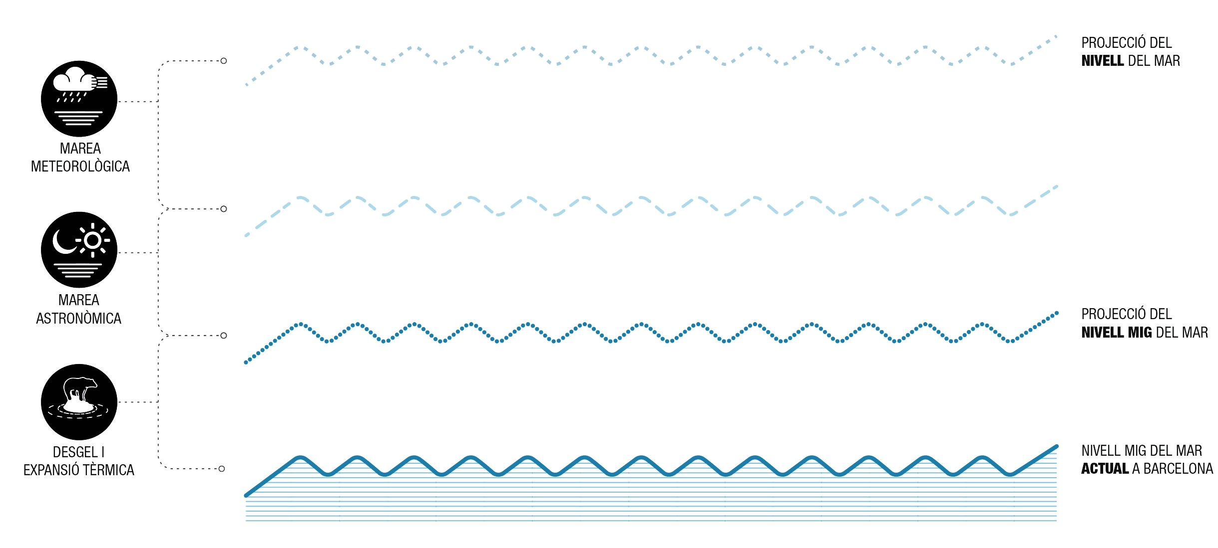
In this case, in addition to the variations generated jointly by the permanent and potential flooding components, the effect of waves is considered.
Extreme events are random and complex phenomena, and are associated with a certain probability of occurrence. Climate change forecasts indicate an increase in the frequency of extreme events, although the magnitude is not expected to vary much. In the case of Barcelona, what was previously associated with 50-year return periods is expected to be associated with 35-year periods by 2050, as shown in the figures below.


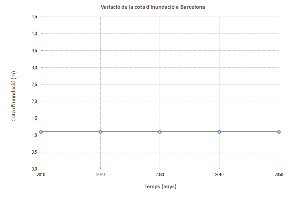
Variation in the flood levels for a 50-year return period in Barcelona. Source: Losada, I., Izaguirre, C. & Díaz, P. 2014. Climate change on the Spanish coastline


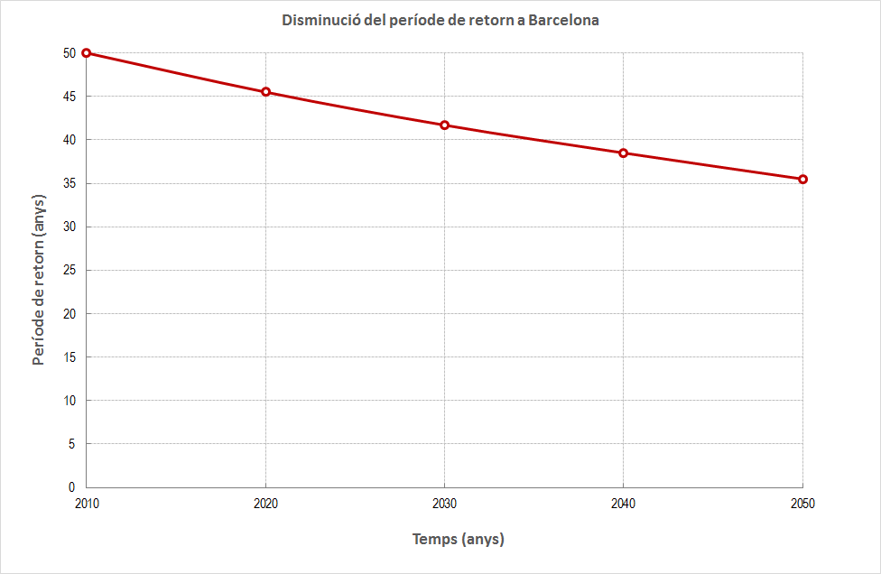
Variation in the return period for current flood levels in Barcelona. Source: Losada, I., Izaguirre, C. & Díaz, P. 2014. Climate change on the Spanish coastline


In order to estimate the level of wave recovery, data from the Green Book on the State of the Coastal Zone in Catalonia, produced by CIIRC (International Coastal Resources Research Centre) in 2010, were used as a reference.
The calculations of these values are prior to the beach stabilisation works carried out by the Ministry between 2006 and 2012, which included new protection elements and extraordinary contributions of sand, which may have slightly affected the equilibrium profiles of the beaches and, therefore, these wave run-up values. However, the average values obtained are 0.8 metres for a normal situation, 2.3 metres for a return period of 10 years (T10), and 2.7 metres for a return period of 100 years (T100).

Effects of maritime flooding on beaches


Based on the data obtained for permanent and potential flooding, and assuming that the current beach profile and extreme wave regime would be maintained, the results of maritime flooding as a consequence of climate change are presented for four representative profiles of the beaches of Barcelona.

These profiles were obtained from topo-bathymetry carried out in October 2016 and are located as shown in the figure below.

Augment de la temperatura
Situation of the profiles chosen by the characterisation of the beaches. Source: Barcelona Regional

Sant Sebastià Beach

 
At present, on Sant Sebastià beach, where the level of the promenade is at the same level as the sand, as on Sant Miquel beach, the potential flooding levels do not exceed the level of the sand and therefore do not reach the promenade area. On the other hand, flooding of the promenade could occur in future climate change scenarios, due to the extrapolation of current extreme waves. In the case of storms associated with a return period of 100 years, in all cases the level of the promenade would be exceeded, while for those with a return period of 10 years, the promenade would only be flooded in the most extreme cases, in the pessimistic and trend scenarios.

Considering only the increase in average levels, and without taking into account the variations that will occur in the profile of the beach due to this rise, a retreat of the dry beach limit of between 3 metres for the compromise scenario and 15 metres for the pessimistic scenario is observed.

Augment de la temperatura 
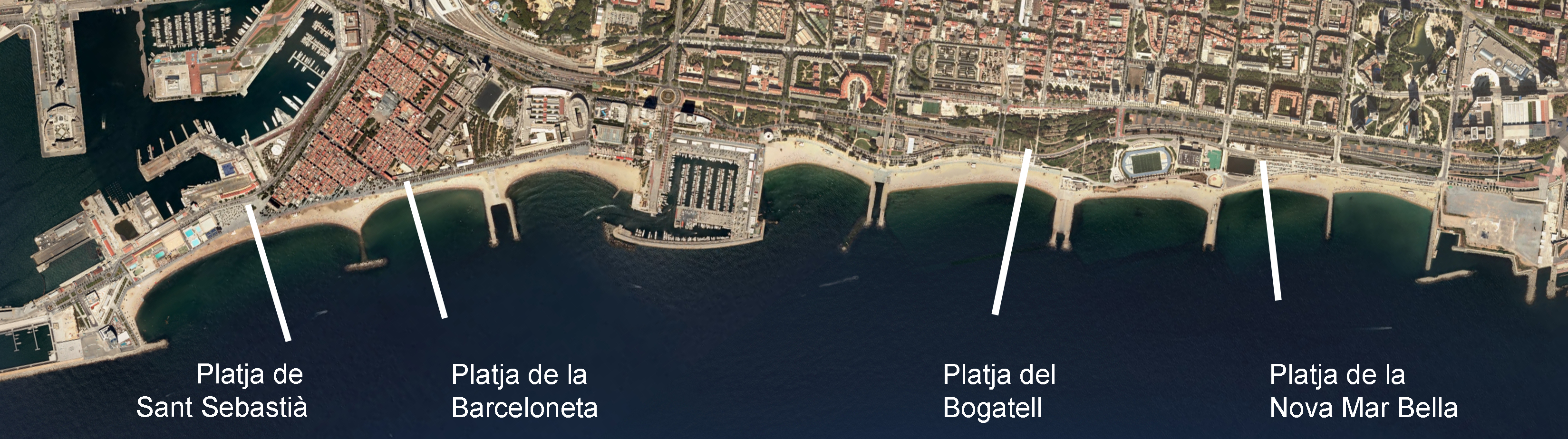
Profiles of the flood elevation at Sant Sebastià Beach beach for the different scenarios considered. Source: Barcelona Regional


Barceloneta beach

 
On Barceloneta beach, where the promenade is located at a higher level but there are premises under the porches (a situation that is also representative of Somorrostro beach), the swell associated with a 100-year return period would flood the porch premises in any of the climate change scenarios considered. In the case of the pessimistic and trend scenarios, the porches would also flood for storms associated with a 10-year return period. As it is a beach with a steep slope in its dry part, sea level rises do not have a significant impact on the graph in terms of the reduction in the width of the beach, between 3 and 8 metres for the pessimistic and committed scenarios, respectively. However, in all probability, this will be one of the beaches that will suffer most in the future, as the rises in sea level will tend to give it a more extended profile, so that the danger of the flood level will have to be added to that of the over-excavation that may occur at the base of the promenade.

Augment de la temperatura 
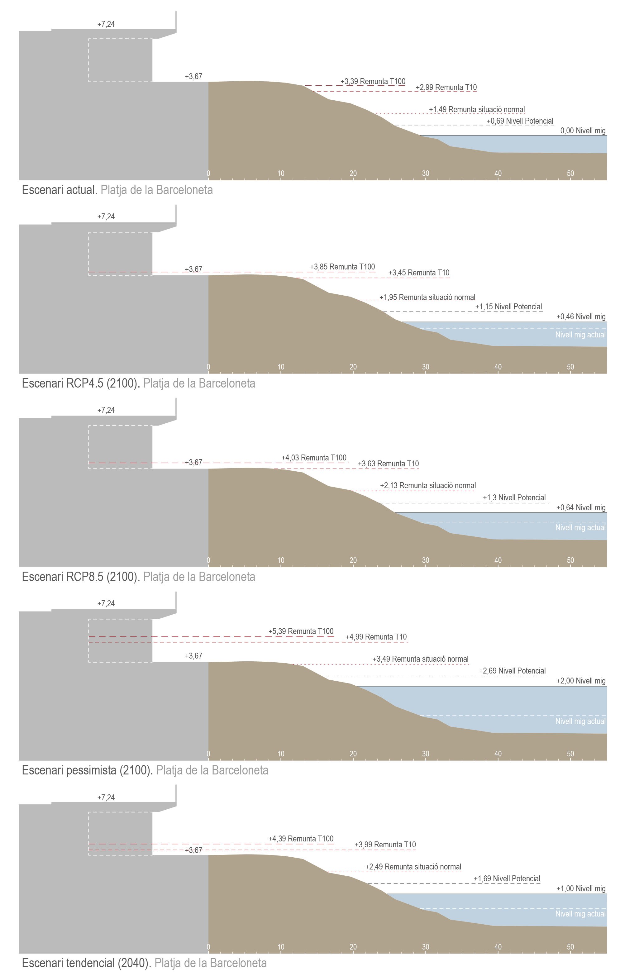
Profiles of the flood level at Barceloneta beach for the different scenarios considered. Source: Barcelona Regional


Bogatell beach

 
Bogatell beach, with a promenade at a higher level and another at sand level (a situation that is also representative of Nova Icària beach), has a gentler slope and increases in sea level have a strong repercussion on the useful width of the beach. In all the climate change scenarios, the waves associated with return periods of 10 and 100 years would reach the level of the lower promenade. In none of the cases, however, would the water flood the upper promenade. Taking into account the same considerations as for the previous beaches, the retreat of the dry beach limit that could occur on the Bogatell beach would be between 3 metres in the compromise scenario and 26 metres in the most pessimistic scenario.

Augment de la temperatura 
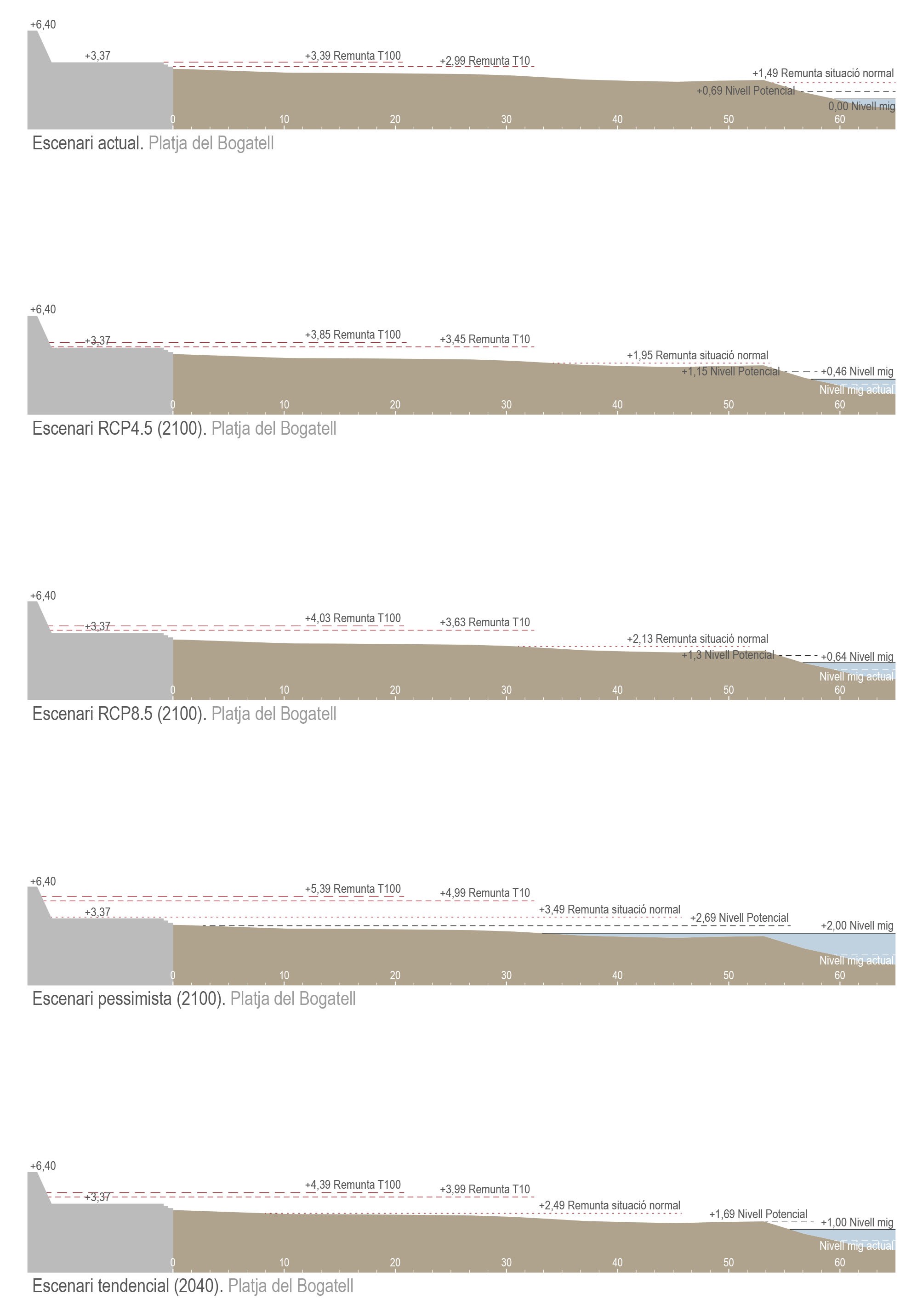
Profiles of the flood level at Bogatell beach for the different scenarios considered. Source: Barcelona Regional

Nova Mar Bella beach

 
Nova Mar Bella beach, with the promenade at a higher level and premises under the porches at sand level, is also representative of the Mar Bella and Llevant beaches. The extreme levels of flooding, in the case of Nova Mar Bella beach, reach the base of the promenade wall in all future scenarios, which would mean that the premises located at sand level would be denied in the event of a storm. Under normal conditions, and for average waves, they would only be affected in the case of the pessimistic scenario. For this beach, the retreat of the dry beach boundary would be between 2 and 12 metres for the compromised and pessimistic scenarios, respectively.

Augment de la temperatura 
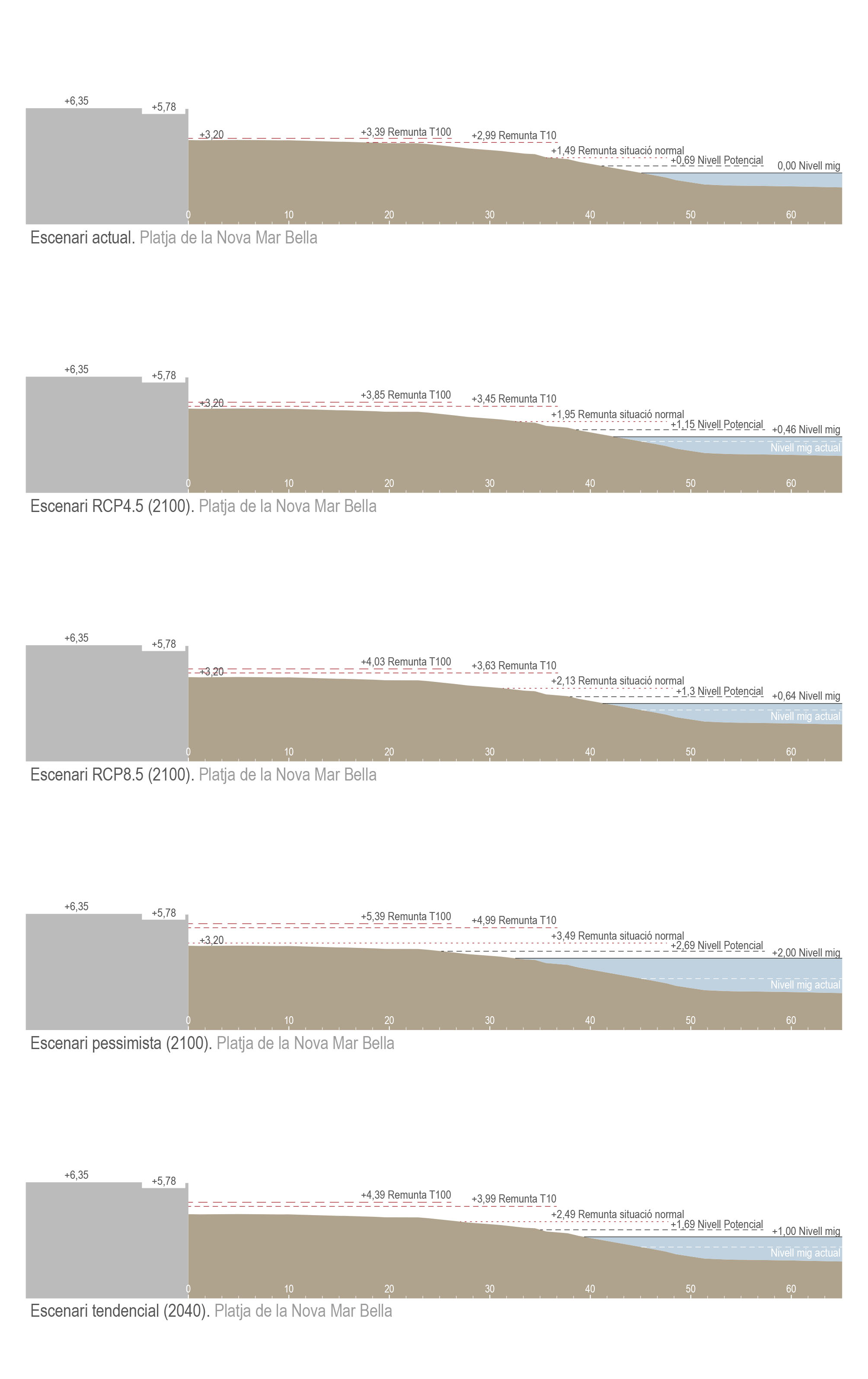
Profiles of the flood elevation at Nova Mar Bella beach for the different scenarios considered. Source: Barcelona Regional

Adaptive capacity


As we have seen, as a consequence of climate change, an increase in the flood level, morphological changes in the beaches and a greater exposure of port infrastructures are foreseen, although in no case would the promenade be affected under normal wave conditions.

The rise in sea level would lead to a retreat of all the city’s beaches, resulting in a loss of useful sand surface area for beach users on all beaches. To deal with the loss of sand caused by sea storms and to protect the seafront, dikes have been built and more than 700,000 m3 of sand have been provided in accordance with the Barcelona Beach Stabilisation Plan for 2009 and 2010.

In order to assess the morphological changes to the beaches as a result of climate change, it is necessary to take into account the variations in incident waves and extreme episodes of storms, the rise in sea level and the dynamics of sediment transport. Their quantification will require localised detailed studies such as the one carried out for the beaches of Sant Sebastià, Sant Miquel and Barceloneta, in order to assess the consequences on the uses and activities carried out on the beaches.

If the current useful surface area of the beaches were to be maintained, the static elements that encase their continental limit would have to be moved back, which would only be possible on the eastern beaches (Nova Mar Bella and Llevant), with the promenade still to be defined and without buildings or important conditioning factors behind it. It is proposed that in the definition of the arrangements to be made on the coastal strip of these two beaches, unconsolidated elements should be proposed which would then allow the possible retreat inland.

On the western beaches, where behind these static elements there are already streets or even buildings, the loss of usable beach area is inevitable. In this case, measures to adapt to climate change should be aimed at reducing the effects of waves through new passive protection elements, such as the configuration of a transitional dune system or the raising of the promenade level.

Augment de la temperatura 
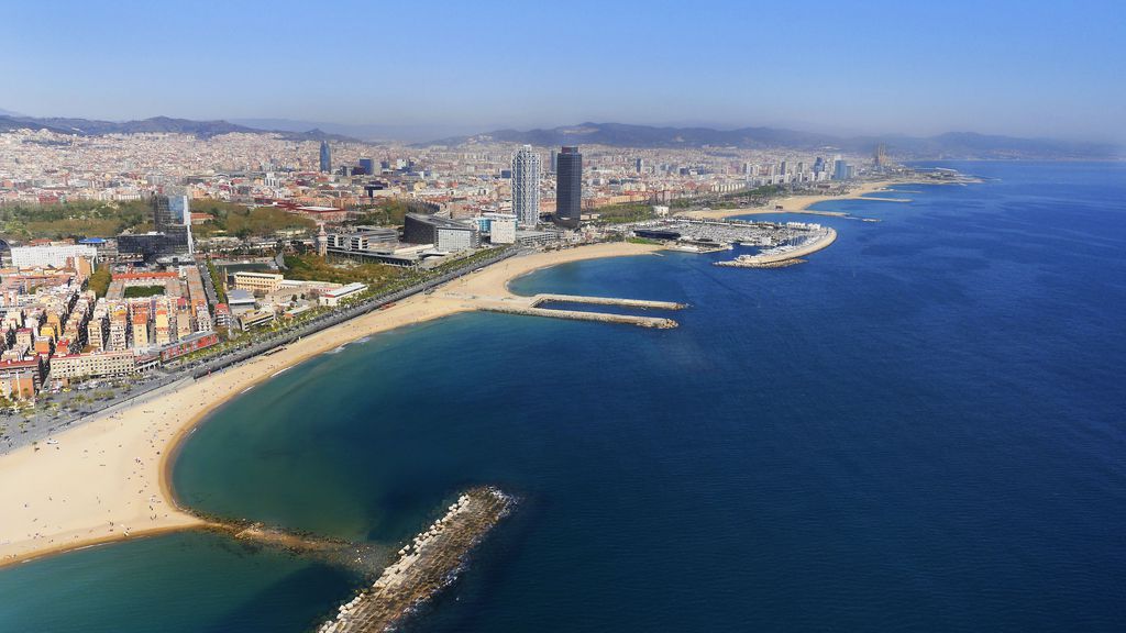
Photograph of the current situation of Barcelona’s beaches. Source: Barcelona City Council image bank (BIMA)

Although not analysed in this document, the rise in average sea levels will have an impact on the city’s ports and the sewer system. With regard to the ports, measures will have to be taken to reduce the overtopping of the breakwaters and internal agitation in the ports. With reference to the sewer system, it will be necessary to consider the new condition of the outflow contour of the combined sewer overflows (CSO) and to analyse the response of the sewerage network for the long-term forecasts, in order to define actions to adapt and improve the current network.

To consult the full study, click HERE (in Catalan).
nt.match(/Trident.*rv\:11\./)) { $('html').addClass('ie11'); }