Back to top

More torrential rains with a negative impact on the city


The configuration and organisation of the city of Barcelona is determined by water. The city's morphology is shaped by its location between the Collserola mountain range, the sea and two rivers, the presence of watercourses and water supply channels. The terrain relief, with steep slopes in the higher part, hills with gentle slopes in the lower parts of the city, together with the high degree of impermeability and artificial elements in the natural watercourses, are just some of the aspects that make Barcelona particularly vulnerable to torrential rainfall, causing flooding in some areas of the city. This effect is increased by the particularities of the Mediterranean climate, characterised by the concentration of most of the annual rainfall in a few episodes of high intensity, mainly in autumn.

Changes in the degree of impermeability in the city of Barcelona and surrounding areas (1956-2009)

The city’s high degree of impermeability means that more rainwater is transformed into surface runoff. Between 1956 and 2009, impermeable surface area in Barcelona increase by more than 2,800 hectares, from 45% to 72% of the total area of the municipality, as shown in the following image.

Source: Impact Study on Climate Change in Barcelona. Barcelona Regional.

The urban hydrological system

In densely populated areas, such as Barcelona, the water cycle is highly disrupted. The percentage of water infiltrating the subsoil is a low as 15%, 30% evaporates and over half of rainwater runs off the surface into the sewer system. When the capacity of the system is insufficient, it becomes over loaded, even exceeding the capacity of the wastewater collection system. This overflow, together with the water that has not been able to enter the system before this and therefore flows on the surface, can lead to flooding, traffic problems, disruption for the public and sewage discharges into the marine environment, causing occasional episodes of pollution.

Augment de la temperatura

Source: Impact Study on Climate Change in Barcelona. Barcelona Regional.

Exposure


Less rain, but more intense.

According to the climate change scenarios analysed, both the committed scenario (reduction of greenhouse gas emissions in line with the Paris-COP24 agreement) and the passive scenario(no reduction in emissions) predict a decrease in cumulative rainfall in the city of between 14% and 26% by the end of the century. Although trends indicate that average annual rainfall will decrease, it will be more intense and concentrated in extreme events. This greater intensity may lead to flooding in certain areas of the city, putting a strain on the city's drainage system. In terms of heavy rainfall, on average there are 3 episodes per year where the rainfall in the first 20 minutes exceeds 60 mm/h, causing flooding and affecting mobility. According to climate change predictions, the probability of extreme rainfall events increases between 10% and 15%.

The first graph shows the number of episodes of intense rainfall (20-minute intensity greater than 60 mm/h) and the maximum annual 20-minute intensity recorded annually since 1995, and the second shows the accumulated rainfall per year since 1914 in Barcelona.


Annual count of episodes with 20-minute intensity higher than 60mm/h. 1995-2018. Source: BCASA.


Annual rainfall in Barcelona, 1914-2018. Source: BCASA
 

In 2018, 10 heavy rainfall events were recorded, some of them exceptional. For example: on 06/09/2018 the highest 20-minute intensity in the BCASA historical series (1995-2018) was recorded, with 169.8 mm/h, equivalent to rainfall with a return period of 300 years, i.e. the amount of rain in a single day for this return period is equalled or exceeded only once every 300 years; on 09/10/2018 the highest 60-minute intensity of the historical series was recorded, with 88.7 mm/h; and 15/11/2018 was the wettest day of the historical series, with 138.5 mm/h of accumulated rainfall. These events made 2018 the fifth wettest year since 1914, breaking a succession of 3 “dry years” (with between 10% and 70% less precipitation than the climatic average, approx. <540.180> mm / year).

The graph below shows the most significant rainfall events since 1995. By combining the maximum 20-minute and 60-minute intensities of the rainfall events, the maximum recorded values are obtained and classified by their return period. In the orange area of the graph are the most extreme episodes, four of which occurred during 2018.


Significant rainfall events in the city of Barcelona. Source: BCASA

Present flood hazard


Current performance of the sewer system

Barcelona's sewer system is designed to drain rainfall with a return period of up to 10 years, i.e. for rainfall with an annual 10% probability of being exceeded. The map shows certain areas where the drainage system has insufficient capacity to carry away the resulting water flow for rainfall associated with a return period of 10 years, resulting in water outflows from wells and drains to the street surface in areas such as Poblenou, Paral.lel-Sant Antoni-Raval or the Diagonal axis between Balmes and Via Laietana, among others. The rest of the network is operating correctly, although under pressure in some sections. These results were obtained using the sewer system model developed by Barcelona Cicle de l’Aigua - BCASA for the Integrated Sewerage Plan (PICBA 06). BCASA is currently working on a new simulation model, within the framework of the preparation of the PDISBA (Comprehensive Sewerage Master Plan for Barcelona), which will allow consideration of not only the network drainage capacity, but also the surface runoff generated.

Source: Impact Study on Climate Change in Barcelona. Barcelona Regional based on modelling by BCASA.

Present flood hazard level

The identification of the areas of the city with the highest flood hazard was based on three factors: sewer system capacity, slope of the land and the catchment surface area. This resulted in a flood hazard map of the city, showing the areas with the highest hazard (in red and orange).

Source: Impact Study on Climate Change in Barcelona. Barcelona Regional.

Future flood hazard


In order to calculate the effects of climate change, the Intergovernmental Panel on Climate Change (IPCC) publishes assessment reports (AR) which are the benchmark for the state of scientific, technical and socio-economic knowledge on climate change, based on so-called emission scenarios. The climate projections in the Climate Plan are based on the latest published assessment report (AR5, 2014), specifically for the RPC4.5 scenario or committed scenario (reduction of GHG emissions in line with the Paris-COP24 agreement) and the RCP8.5 scenario, or passive scenario (no reduction of GHG emissions). When this flooding study was developed, however, the simulations of network operation in these scenarios were not yet available, and those of the previous report were used, where B1 is similar to the committed scenario and A2 similar to the passive scenario.

BCASA simulated the performance of the primary sewer system with its 2016 configuration, without including any of the actions planned for the medium/long term, considering the B1 and A2 climate change scenarios, and with the design rainfall associated with the 10-year return period estimated for 2040. In all simulations, a sea level rise of 0.94 metres over the current level was considered.

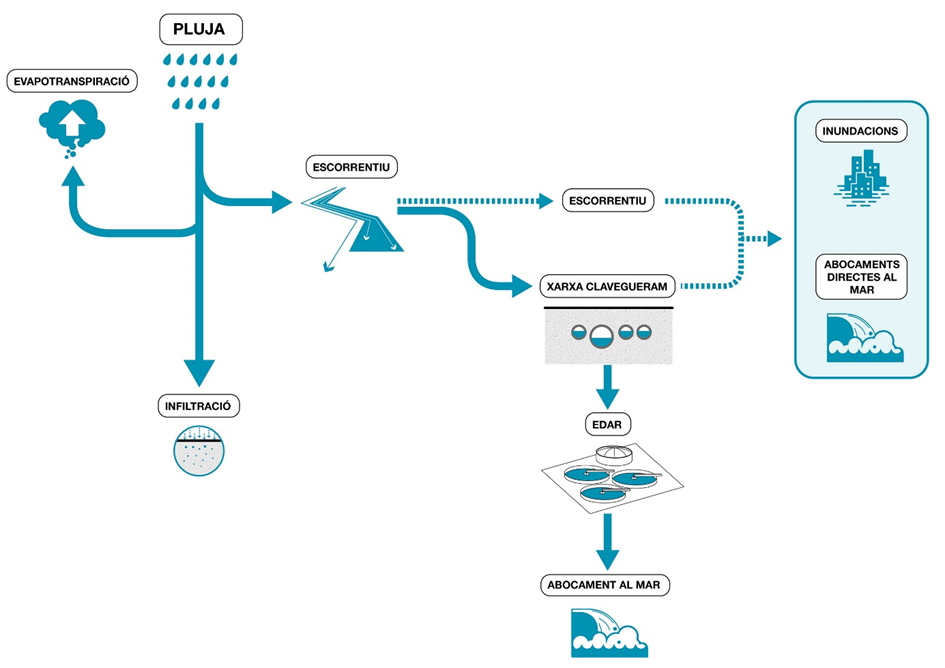
A simulation of the current sewer system for the two climate change scenarios has been carried out to estimate the effects that climate change may have on the city.


Performance of the sewer system in the medium-term committed scenario (2040)

A worsening of the performance of the sewer system is observed in the simulation of the medium-term committed scenario, with an increase of up to 12% in the sections with surface water flows (pink), up to 7% in the sections where the water flows 50 cm below ground level (brown) and up to 23% in the sections that operate under pressure (yellow). The remaining 58% of the network works correctly.

Source: Impact Study on Climate Change in Barcelona. Barcelona Regional based on modelling by BCASA.


Comparison of the current performance of the sewer system and in the medium-term committed scenario (2040)

The results obtained when comparing the operation of the drainage system today with the performance of the system in the committed scenario for rainfall with a return period of 10 years show the sections that would their status to operating under pressure at 0.5 metres below ground level, in blue, and those where overflows would occur, in red.

Source: Impact Study on Climate Change in Barcelona. Barcelona Regional.


Performance of the sewer system in the medium-term passive scenario (2040)

Simulating the current sewer system for an estimated 10-year return rainfall for 2040 with the climate change predictions for the passive scenario shows a worse functioning of the drainage system, with up to 13% of sections with overflows in the network (pink), up to 30% of sections under pressure (yellow) and 0.5 metres below ground level (red). In this scenario, 55% of the network works in free laminar flow (green).

Source: Impact Study on Climate Change in Barcelona. Barcelona Regional based on modelling by BCASA.


Comparison of the current performance of the sewer system and in the medium-term committed scenario (2040)

Although the differences between the committed scenario and the passive scenario are minimal, network performance becomes more critical in the passive scenario, as the number of sections that become pressurised, in blue, and the number of sections where water flows on the surface, in red, increases. The map shows how deficiencies in the drainage system are exacerbated by the effects of climate change in the areas of the centre of Poblenou, the Badal axis, Sant Antoni-Raval Sud, the Diagonal axis and Sant Andreu.

Source: Impact Study on Climate Change in Barcelona. Barcelona Regional.


Flood hazard level in future climate scenarios

Combining the results obtained from the simulation of the sewer system performance for the committed and passive scenarios with the surface water behaviour variables (slope and catchment surface area) of the hazard map provides the following maps showing the future flood hazard level in the medium term (2040).


Flood hazard level in the medium-term committed scenario (2040)

The map shows the areas of the city where the vulnerability of the system is most evident. The sections marked in red and orange represent the areas with the highest hazard level, highlighting the areas of Poblenou, the Diagonal axis, Sant Andreu, Badal and Sant Antoni, which is where the areas that will become critical in the future are concentrated.

Source: Impact Study on Climate Change in Barcelona. Barcelona Regional.


Comparison of the present flood hazard with the medium-term committed scenario (2040)

Comparing the results from the simulation of the hazard level for the committed scenario with the present flood hazard level in the sewer system shows the areas of the city where the flood hazard is increasing. The areas of the system with the most critical increases in flood hazard in the city are marked in red and orange.

Source: Impact Study on Climate Change in Barcelona. Barcelona Regional.


Flood hazard level in the medium-term passive scenario (2040)

Comparing the current hazard level with the hazard level resulting from the simulation of the passive scenario shows that the differences between the two future scenarios are minimal; however, in the passive scenario there is a sharper increase in the hazard level in Poblenou, Sant Andreu, Badal and the Diagonal axis. The map shows the areas in which the system his more vulnerable in red and orange, while the areas of the city where flooding is not expected to have an effect, basically associated with a steep slope of the terrain, are marked in blue and green.

Source: Impact Study on Climate Change in Barcelona. Barcelona Regional.


Comparison of the present flood hazard with the medium-term committed scenario (2040)

Comparing the results obtained from the simulation of the flood hazard level for the passive scenario with the present hazard level in the sewer system shows the areas of the city where the flood hazard is increasing. The areas of the city with the most critical hazard increase in the system for the passive scenario are marked in red and orange .

The flood hazard level for the passive scenario is slightly higher than in the committed scenario.

Source: Impact Study on Climate Change in Barcelona. Barcelona Regional.

Adaptive capacity

Since 1988 Barcelona City Council has had special sewerage plans in place to improve the capacity of the urban drainage system and reduce the probability of flooding episodes, which the city has historically suffered, and direct discharges into the marine environment.

The 1988 Special Sewerage Plan (PEC) led to the construction of large collectors in the Olympic Village and the Ronda de Dalt ring road and the construction of four retention tanks.

In 1997 the Special Sewerage Plan for Barcelona (PECLAB) was drawn up. This Plan incorporated planning of new Stormwater detention tanks in addition to those already planned in PEC 88, and a series of large collectors at critical points with insufficient water capacity.

In 2006 the Integrated Sewerage Plan (PICBA) was published. This document provided a detailed analysis of the performance of the sewer system and incorporated the actions carried out between 1997 and 2006 and the planning of 10 retention tanks, 14 stormwater detention tanks (to protect the receiving environments, sea and rivers, from discharges from the network) and 2 open-air lamination basins for extraordinary rainfall (T> 10 years), as well as 8 large collectors.

The following images show the locations of the stormwater detention tanks built up to 2018 and those planned for the future.

Existing and planned stormwater detention tanks in 2018

Map of existing stormwater detention tanks (2018). Source: BCASA


Map of planned stormwater detention tanks (2018). Source: BCASA


Barcelona Cicle de l’Aigua, SA (BCASA) is currently drafting the Comprehensive Sewerage Master Plan for Barcelona (PDISBA), which will update the PICBA. This plan includes other actions to reduce the risk of flooding.

With regard to the degree of impermeability, which determines percentage of rainfall that becomes surface runoff, its effect is not only limited to the potential amount of water that can flow over the surface, but also the way in which it does so. Increased impermeability increases the peak flow and shortens the time for this peak to appear, thereby reducing the reaction time for taking measures to mitigate its effects.

In this context, both the PDISBA and the Climate Plan propose measures to increase infiltration, such as:

  • Introducing sustainable urban drainage systems in the city (drainage ditches, infiltration-retention areas, permeable paving, etc.), prioritising those areas where they are most efficient, in order to increase infiltration and evapotranspiration, and consequently reduce runoff or increase the time it takes to reach the peak.

  • Encourage the construction of green roofs on new or existing buildings where possible.

  • Increase the permeable green surface of the city (parks and flowerbeds with direct infiltration into the ground). Improve knowledge about the degree of occupation and uses of the city's subsoil and advance in its planning, assessing the possibility of establishing reserve spaces.

  • Build recharge basins at high points of the city, which facilitate infiltration and generate a retention and layering effect on the flood flow.

To consult the full study, click HERE (in Catalan).
nt.match(/Trident.*rv\:11\./)) { $('html').addClass('ie11'); }