Introduction
The themes analysed in this chapter aim to shed light on the obstacles and opportunities faced by a public space when fulfilling its more social, relational functions through the type of activities organised there. Despite a lack of reference studies on this issue and the added problem that this information has never before been collected by the City Council in this way, what follows is an exercise, a first attempt at territorialising the activities organised in the public space and studying these activities’ potential to weave a community fabric.
In this set of maps, the overarching question ‘What impact do organised activities in the public space have on the relationships between residents of the neighbourhood?’ was used to formulate two other sub-questions that help to frame the answer in the form of two maps:
Map A: Which public spaces in the city are home to the highest density of activity?
Map B: Which parts of the city have the most potential for generating social cohesion among residents based on the activities carried out there?
In this chapter, each map answers one of the sub-questions posed. Both stem from the same layer of information – the activities organised in the public space – but each offers a different reading of it. The first calculates the density of the activities taking place in the public space, while the other assesses these activities’ capacity to generate social cohesion among the residents of the neighbourhood where they are carried out.
In this respect, the study was intended to be a reflection on the concept of public spaces’ overcrowding, as well as on the risk of losing community fabrics. On the latter subject, it is important to define the point at which there are too many activities organised and to examine whether or not these activities really respond to residents’ needs and wishes. Too many activities or activities that do not fulfil the community’s needs can harm the social function exercised by public spaces. An aim for the future could be to establish intensive use limits according to the type of activity being organised. A lot is said about the benefits of the public space as a generator of social cohesion, thanks to its nature as a meeting space, but how can this be measured? In Barcelona, an especially dense city, it is particularly important for the public space to carry out its function of providing this kind of service.
Density of activities
Which public spaces in the city are home to the highest density of activity?
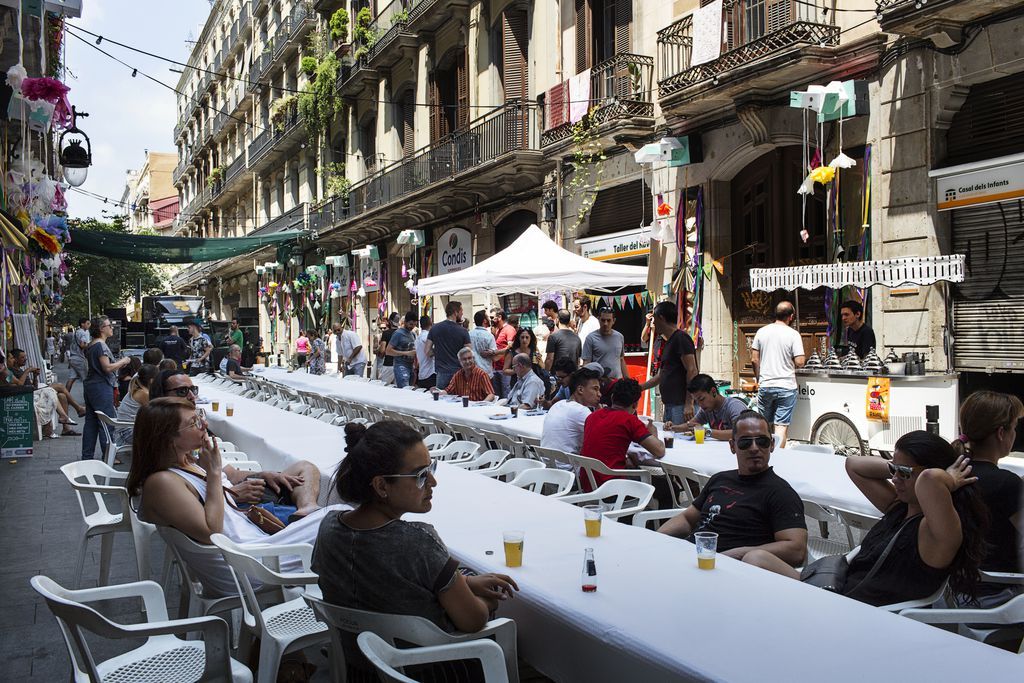
The activity (or event) density map refers to the index of activities in the public space and illustrates the intensity of the activities organised there. Data is processed and displayed through a calculation of the density of the activities collected from a combination of event calendars. These include both activities that take place in a single location and travelling activities. The events in each hexagonal section are added together to generate a public space usage density map.
Among more than 2,000 activities that took place in 2018 analysed here, 762 venues were detected, which suggests that the activities are quite spread out. The risk is that a small number of spaces (2%), especially in the city centre, see a very high density of activities each week. For example, an activity is organised at least every other day on Plaça de Sant Jaume, and at least every three days on Plaça de Catalunya. As for the time at which these activities take place, 44% are carried out in the morning and 33% in the evening. The neighbourhoods at the highest risk of suffering from an excess of activity in their public spaces are Sant Antoni, El Gòtic, Vila de Gràcia and Sant Andreu, in that order.
Social cohesion
Which parts of the city have the most potential for generating social cohesion among residents?
The social cohesion map aims to interpret how the potential for social cohesion among residents of the area varies according to the activities organised there. With this premise as a basis, the information collected from the city’s event calendars has been examined and the spaces with potential for creating situations for social relations have been assessed. A cohesion coefficient has thus been created and will be explained below. Other data on elements that could potentially contribute to improving social cohesion has also been included in the analysis. These elements include neighbourhood and parents’ associations, local businesses, and street markets and fairs.
The data display criteria are based on a cohesion coefficient assigned to each activity, according to the following guidelines
| Cohesion coefficient | Type of activities |
|---|---|
| 0 | Sporadic or annual activities organised in a specific space without there being any relationship with the space as such or with local residents (e.g. protests, marathons or large, city-wide events). |
| 2 | Non-food markets and fairs. |
| 4 | Large sporadic or annual activities in which residents play a large part, in terms of both organisation and participation. This category would include the Festa Major in Gràcia, for example. |
| 5 | Periodic neighbourhood food markets and local businesses. |
| 6 | Small sporadic or annual activities, mainly neighbourhood-based, often organised by civic entities in the neighbourhood or by the City Council to energise the neighbourhood. This category includes anything from neighbourhood festivals to family workshops, activities for elderly people and concerts for young people. |
| 8 | The highest coefficient has been established for the headquarters of parents’ and neighbourhood associations. In general, this type of association is considered the most conducive to social cohesion in neighbourhoods. Therefore, although these are not specific activities in the public space and the headquarters of these associations do not necessarily represent the venue where the activities are organised, this has been deemed an important enough phenomenon to be included in the study. |
According to the criteria and scores in the table, the activity or space’s value has been assigned to the hexagonal cell where it takes place, and 50% of the cohesion value of the activities carried out within 100 metres has been added to this figure. This creates a ‘heat map’ of activity density. The sum of the cohesion values assigned to each space or activity, in each hexagonal section, generates a density map indicating cohesion potential in the public space.
Out of a great number of activities, the concentration distribution according to type of activity is as follows:
• Most local businesses: Vila de Gràcia, La Dreta de l’Eixample, El Raval, Sagrada Família and L’Antiga Esquerra de l’Eixample.
• Most street markets and fairs: El Raval; Les Corts; Sant Pere, Santa Caterina i la Ribera; and El Gòtic.
• Most activities with cohesion potential: Vila de Gràcia, La Dreta de l’Eixample, Sant Andreu del Palomar, Sant Gervasi - la Bonanova, and Les Corts.
Aggregating all the parameters considered, the neighbourhoods with the most potential to generate social cohesion in their public spaces are Vila de Gràcia, La Dreta de l’Eixample, Sant Andreu del Palomar, Sant Gervasi - la Bonanova and Les Corts.
Related initiatives
Vulnerability maps can guide priority action in the city on a territorial level. In this case, they provide a preliminary snapshot of activities that take place in the city’s public space. The first map in particular indicates that Barcelona is a city with several activities organised across its territory, although these are mainly concentrated in specific areas, often overlapping with city areas most under pressure from tourism.
This chapter has developed a methodology to carry out an initial risk assessment regarding the impact of activities on the public space. A comparison of the two maps offers highly interesting findings. The areas with the most concentrations of activity are practically a negative image of the areas with the most cohesion potential. In other words, the activities organised in these ‘overcrowded’ spaces do not contribute towards enriching the neighbourhood’s social fabric. For instance, this occurs across most of the coastal part of the district of Sant Martí, and on Diagonal between Glòries and El Forum in the same district. In L’Eixample, the same thing occurs on Gran Via, between Passeig de Gràcia and Plaça d’Espanya, and in Ciutat Vella around the Ciutadella Park, or, more specifically, on Passeig de Pujades, Passeig de Lluís Companys and Ronda de Sant Pere. In the district of Sants, the same phenomenon occurs on Avinguda de la Reina Maria Cristina and the surrounding area.
It is important to remember that these maps require a large-scale reading and risks must be contextualised globally. They have been generated on a city-wide scale, and although a territorial degree of detail was sought, they are an interpretation based on approximations and will require a specific study on the selected areas of action. To this end, Barcelona City Council and its Tourism Department have long been working to improve the management of busy spaces, which largely coincide with the spaces detected in the interpretation of both maps. The city is leading projects to manage spaces with a large tourist presence, such as CityFlow, part of the European project KIC Urban Mobility. The aim is to develop a support system to manage crowds and to study the redistribution of flows around the Sagrada Família or the closure of Plaça de Sant Felip Neri during school hours so that the local school can use it again.